
Large urban centre at the south western edge of Greater Melbourne
Werribee is a rapidly growing city on the Werribee River. It had a population of over 55,000 in 2021 and was anticipated to exceed 100,000 by the early 2040s. It is recognised as being part of Greater Melbourne being the south-westernmost suburb of the state capital. The City of Werribee now includes the surrounding suburbs of Werribee South, Wyndham Vale, Hoppers Crossing, Tarniel, Truganini, Williams Landing and Point Cook. The latter has a large air force base.
The CBD of Werribee is located on a section of the old Princes Highway which has been bypassed by the Princes Freeway between Melbourne and Geelong. The main attractions in the area are the remarkable Werribee Park mansion, the Werribee Open Range Zoo and the important historic buildings at Point Cook.
Location
Werribee is located on the Werribee River 32 km south-west of Melbourne.
Origin of Name
The first European settlement in the area was named Wyndham but, because the river had already been named Werribee, it was soon abandoned in favour of Werribee which was believed to be a local First Nations word for either “spine” or “backbone” – a description of the curve of the river.
Things to See and Do
Werribee Historical MuseumLocated at the corner of Duncans Road and Watton Street, the local historical society museum is located in the second shire office building (1893). The museum has a collection of documents, maps and photos which can be accessed every Tuesday from 10.00 am – 3.00 pm and every Saturday from 10.00 am – 1.00 pm, tel: 0468 435 090 or check out https://www.wyndham.vic.gov.au/venues/werribee-historical-museum.
B-24 Memorial Liberator RestorationLocated in a hangar at the corner of the Princes Highway and Farm Road, is a restored B-24 Liberator Bomber – one of only eight left in the world. It took over 250,000 hours of volunteer work to restore the bomber as a memorial to the 20,000 Australians who flew and serviced the aircraft during World War II. It was put together with pieces from all over the world with the fuselage coming from Moe and the wing from the New Guinea highlands. The hangar is open Tuesday, Thursday and Sunday from 9.30 am to 3.30 pm. For more information tel: (03) 9731 1263 or check out https://www.b24australia.org.au.
Werribee Park Mansion Werribee Park Mansion is located 5 km south of the centre of Werribee via K Road. It is signposted from the Princes Freeway. This remarkable basalt and sandstone mansion is widely regarded as Victoria’s finest rural colonial homestead. The hugely successful Scottish graziers,
Thomas and Andrew Chirnside, commissioned the building and it was completed between 1874 and 1877. It was built in an Italianate style which echoes 16th century Italian Renaissance Architecture. It has 60 rooms, a central tower and single-storey arcade. It was a symbol of the success of the Australian wool industry.
Both Thomas and Andrew had huge holdings and reputedly had over one million sheep. Not surprisingly they built the residence as a kind of antipodean answer to the British country house. Thomas, suffering ill-health and related depression, shot himself in the estate’s washhouse in 1887. Andrew died in 1890 and his wife in 1908. His son George then inherited the mansion. He broke up the estate to enable the establishment of the Werribee State Research Farm in 1912 and the RAAF base at Point Cook in 1921 then sold the mansion to the Jesuits in 1923. They used it as a seminary, making major additions to the house in the 1920s and 1930s, including the tower. The mansion and grounds were purchased by the Victorian government in 1977.
The driveway begins at the grand entry gates and gatekeeper’s lodge and passes the Floriana Parterre, an ornamental arrangement of flower beds which is in full bloom from February to March. It is the focal point of the formal gardens which cover 10 hectares. Completed in 1882, they were allegedly laid out by the curator of the Melbourne Botanical Gardens and, like their English counterparts, they feature not only a parterre, but also a lake, grotto, glasshouses, meandering pathways, extended vistas and European flora.
The mansion is characterised by lavish Victorian interiors. The aim has been to restore the mansion to the time in the 1870s and 1880s when it was owned by the Chirnsides. Most of the Chirnsides’ furniture was made in Edinburgh and shipped in 58 crates. A third of these items remain. While in London in 1881 Thomas Chirnside acquired a collection of 73 paintings by contemporary artists and ‘old masters’, 20 of which remain.
The drawing room features an exceptional cut-glass chandelier, ebony-and-gilt cabinets, an ottoman and chenille carpeting. There is a gracious staircase with rococo statue-lamps, a billiard room with a panelled ceiling and carvings, a marble-paved conservatory featuring a fine plastered ceiling and etched-glass windows, a main hall with mosaic floor, Corinthian columns and gold-leaf, a library, bedrooms, dining room and morning room.
The kitchen and servants’ wing are an insight into the working lives of the domestic staff required to maintain this grand lifestyle.
In the fashion of the day the estate was essentially a self-sufficient village. There is a farm section at a small distance from the mansion which retains a number of bluestone buildings – the stables, blacksmith’s shop, men’s hut, implement shed, ration house and employee’s cottage. Farmhands are in attendance.
The 140 ha estate also includes a bluestone river ford that linked the two parts of the estate; an ornamental lake with an island that features a grotto; some glasshouses; a section of the original Melbourne to Geelong road; and an earlier bluestone homestead (1857) which is surrounded by a ha-ha, a sunken bluestone wall which stopped animals from accessing the garden while preserving views of the garden.
The shrubland, woodland and stands of river red gums are home to great egrets, willy wagtails, the Australian white ibis, swamp harriers, magpie larks, migratory waders, cormorants and ibis. There are also platypuses, water rats, eastern long-necked tortoises, the forest eptesicus bat and plenty of frogs in and around the river.
The mansion is open Monday to Friday from 10.00 am to 4.00 pm and Saturday and Sunday from 10.00 am – 5.00 pm. Check out https://www.parks.vic.gov.au/places-to-see/parks/werribee-park/things-to-do/werribee-park-mansion for more details.
Victoria State Rose Garden
The Victoria State Rose Garden is located near to Werribee Park at 206K Road, Werribee South. It features over 5000 plants from 100 species in the shape of a giant Tudor rose and is at its best from November to April. The gardens cover 5 hectares and are open seven days a week – from 9.30 am – 6.00 pm between October and April and from 9.30 am – 5.00 pm from April to October. Entry is free. For more information check out https://www.vicstaterosegarden.com.au.
The National Equestrian Centre
Located at 206K Road, Werribee South, just before Werribee Mansion,the National Equestrian Centre combines elite horse training and major equestrian events. It was opened in 1983 and has facilities suitable for both indoor and outdoor equestrian activities including dressage, show jumping, polo and cross country. The facilities include 180 stables, 370 day yards, 250 campsites spread over 34 hectares. For more information check out http://wpnec.com.au or tel: (03) 9741 7672.
Werribee Open Range Zoo
Located on K Road, the Open Range zoo is on over 225 ha of land adjacent to Werribee Mansion. It is open daily from 9.00 am to 5.00 pm. There are basically three tours and experiences at the zoo.
* African River Trail – where visitors walk through an area with lions, hippos, cheetahs, monkeys, gorillas, wild dogs, servals, leopard tortoises, meerkats and other African animals. There is a Gorilla Keeper Talk at 1.45 pm every day except Tuesday when it is at 11.30 am.
* Safari Tour – travels through a section of African savannah on a special bus/train and inspects camels, Przewalkski’s horses, ostriches, oryx, blackbuck, eland, nyala, addax, white rhinos, zebras and giraffes. The buses operated throughout the day.
* Australian Trail – this section of the zoo is open from 9.00 am – 4.30 pm daily and allows visitors to see kangaroos, emus, brolgas, koalas, pygmy possums, birds, reptiles and mammals.
For more information check out https://www.zoo.org.au/werribee or tel: 1300 966 784.
Werribee River WalkWalking Maps (see https://walkingmaps.com.au/walk/2540 for a map and details) have detailed an easy walk along Werribee River which starts at Comben Drive. It is 4.5 km long, takes a little over an hour, and winds along the river bank passing bird life on the river, a number of public sculptures and finishing at Riverbend Historical Park.
Walking Maps list nine places of interest on the walk:
1. View of Werribee River from the bridge2. Giant Sewing Needles Sculpture – created by Grant Finck “Three sets a giant sewing needles walk across the lawns surrounding Werribee River. The sculpture consists of two main elements, stylized representations of sewing needles and woven mesh.”
3. Native ferns in the river4. Fauna – Keep your eyes open for “common species such as parrots and lorikeets, and the threatened Growling Grass Frog. Watch how these ducks navigate moss-like Azolla.”
5. Shaws Road Bridge6. Presidents Park7. Diversion Weir8. Riverbend Historical Park – an excellent picnic spot where, in 1889, the Chaffey brothers undertook early experiments with the irrigation of farmland.
9. Walk, bus or kayak back to Werribee10. Wyndham Park
Other Attractions in the Area
Point Cook RAAF MuseumLocated at 480-490 Point Cook Road, the RAAF Museum is the official museum of the Royal Australian Air Force. The first RAAF base in Australia was established at Point Cook in 1921. It is claimed to be the oldest continuously operating military base in the world.
The museum houses extensive displays of memorabilia relating to the history of the RAAF, of Point Cook, and the role of women in Australia’s military conflicts. There are numerous special exhibits, including one on World War I flying ace, Baron von Richtofen.
The museum has a display of static aircraft in the grounds of Point Cook. As well there is a Heritage Gallery which explores the historic nature of military aircraft in the Southern Hemisphere with items dating back to 1916. A Training Hangar, a Technology Hangar, and Aircraft Display Hangar, a Restoration Hangar and a Strike Reconnaissance Hangar.
For more information tel: (03) 8348 6040 or check out https://www.airforce.gov.au/raaf-museum. The museum is open from 10.00 am. to 3.00 pm from Tuesday to Friday and from 10.00 am to 5.00 pm on weekends and public holidays.
Point Cook Coastal Park and Cheetam Wetlands
Located 10 km east of Werribee, the Point Cook Coastal Park (863 ha), Point Cook Marine Sanctuary and Cheetham Wetlands are one of the last relatively unspoiled ecosystems on Port Phillip Bay.
They include a lookout tower, picnic shelters, gas BBQs, childrens’ playgrounds, change rooms, clean toilets, and paved walks to the unspoilt shore which boasts a swimming beach, walking trails and birdlife (it is known as one of the best places in the world to see migratory wading birds) which can be observed from Spectacle Lakes birdhide or from the Cheetham Wetlands Tower which offers views over ponds which are populated in summer by birds migrating from the northern hemisphere including the eastern golden plover from Siberia and Alaska.
The wetlands, salt marsh and beach sand flats are visited by birds including the endangered orange-bellied parrot. The rare Altona skipper butterfly can be found in the area. The Point Cook Marine Sanctuary, declared in 1982, protects the native flora and fauna in the park. The sanctuary forbids fishing, spearfishing, open fires, cats, dogs and horses on or near the reef.
The park’s vegetation was altered by European settlement and now consists of remnant basalt plains grassland, with areas of coastal salt marsh, grassy wetland and sedgeland. The park is open daily from 8.30 am to 5.00 pm, tel: 131 963.
Point Cook Homestead
Located at 1 Point Cook Homestead Road, the Point Cook Homestead and stables are located on the edge of Port Phillip Bay. The Parks Victoria website explains: “The Point Cook Homestead Precinct is … a rare example of early Victorian rural architecture. The precinct is an area of 12.5-hectares contained within the 464-hectare Point Cook Coastal Park.
The precinct includes buildings, garden and landscape listed by Heritage Victoria.” See https://www.parks.vic.gov.au/projects/point-cook-homestead-precinct for more detail.
It is a large, single-storey bluestone house which was built in stages from around 1850 to 1857 for Thomas Chirnside who used it as the family residence until the completion of Werribee Mansion.
The Balance Architecture page (https://balancearchitecture.wordpress.com/2017/03/30/point-cook-homestead-and-werribee-mansion) notes: “Consisting of seven rooms, with an attached servants quarters wing of four rooms, there was also an attached weatherboard wing. The front veranda faces the coast, the homestead being a stones throw from the beach. A further detached building served as ‘meat house’, dairy room and rabbiters hut.
This building was the earliest structure on the site and it was believed to have been constructed in 1849.” The site is managed by Parks Victoria. Tel 13 19 63 or check https://www.parks.vic.gov.au/explore/parks/point-cook-coastal-park.
Point Cook Stables
Near the house are The Stables which, like the main house, are listed on the National Trust Database which explains their significance: “The Stables, Point Cook Homestead, were erected prior to 1861 in proximity to the homestead. Constructed in random coursed bluestone with gabled ends and slate roofs, the stables are single storied with a loft above. Lean-to roofed wings extend to the rear at each end and a timber section infills between them. The building originally contained a coach room, saddle and groom’s room, loose boxes and a hay loft.” See http://vhd.heritage.vic.gov.au/search/nattrust_result_detail/66867 for more information.
There is an informative sign inside the stables which notes: “In the early 1860s Thomas Chirnside imported valuable horses for breeding at Point Cook and the bluestone stables probably were constructed at that time or a little earlier. The property is said to have had three race tracks.
One of the early sires at Point Cook was Ladykirk whose progeny included Haricot which won the 1874 Melbourne Cup and Tom Kirk, winner of the Caulfield Cup of 1880. Racing activities at Point Cook attracted considerable attention in 1876 when an unsuccessful attempt was made to poison Newminster, the horse which was favoured to win the Melbourne Cup of that year. The champion horse survived and went on to win the Derby, the Geelong Cup of 1878 and the first Caulfield Cup the following year.
Mount Rothwell Archaeological Area
Mount Rothwell Archaeological Area is located 20 km south-west of Werribee via Bulban Road. Permission is required to access the area (see below). It is one of only four known Aboriginal stone arrangements in Victoria and one of the most spectacular in Australia, consisting of 95 basalt blocks which have been carefully arranged in an oval with a circumference of 151 metres.
In Rock Art Research, an academic paper titled Wurdi Youang: An Australian Aboriginal Stone Arrangement with possible solar indications explains: “The Wurdi Youang stone arrangement, also known as the Mount Rothwell archaeological site … lies near the small town of Little River, between Melbourne and Geelong, and was declared a protected site in 1977 by the Victorian Archaeological Survey.
The site is traditionally owned by the Wathaurong people (also known as Wada Wurrung), whose land extends westward from the Werribee River to Fiery Creek beyond Skipton, and northward from the south coast to the watershed of the Great Dividing Range north of Ballarat. To protect the site, the precise location is not given here, but access may be gained after obtaining permission from the traditional owners via Aboriginal Affairs Victoria.
“Wurdi Youang consists of a roughly egg-shaped ring of about 100 basalt stones, about 50 m in diameter along the major axis, which is aligned east-west. The stones range from small rocks about 0.2 m in diameter to standing stones up to 0.75 m high, some of which appear to be supported with trigger stones. Lane and Fullager (1980) estimate their combined mass to be about 23 tonnes. They all appear to be potentially movable, rather than being part of the bedrock. Particularly prominent are a group of three large stones, about 0.6 m high, at the western end of the stone arrangement. They are located at the highest point of the stone arrangement, which is built on land that slopes downwards from its western end to its eastern end, with a total fall across the arrangement of about four metres.”
Cycling
Werribee is well served with bike paths and bike lanes.
Major trails include:
* The Federation Trail – from Werribee River to Millers Road, Altona North;
* The Werribee River Trail – from Davis Creek, Tarneit, connecting with the Federation Trail, and continuing south towards Werribee Park.
Serendip Sanctuary
Located 29 km south west of Werribee, the Serendip Sanctuary is a 250 ha grassy woodlands and wetlands rich in kangaroos, wallabies, emus and a huge variety of birdlife. It is home to over 150 species of birdlife common to the western plains of Victoria.
The Wildlife Walk through the sanctuary offers close encounters with wildlife including emus and Eastern Grey Kangaroos grazing to viewing areas, hides and flight aviaries perfect for bird watching. It is possible to see Brolgas, Whistling Kites soaring above, Yellow-billed Spoonbills wading through the shallow water, or even Tawny Frogmouth hidden in the bushes.
The sanctuary’s captive breeding program creates an opportunity of viewing rare and threatened species such as brolgas, Australian bustards, Cape Barron geese, Bush stone curlew and magpie geese. Check out https://www.parks.vic.gov.au/places-to-see/parks/serendip-wetlands-education-facility for more information. There are guided tours on the weekends.
Werribee River
The Werribee River is a perennial river of the Port Phillip catchment that is located on the expansive lowland plain southwest of Melbourne, Victoria, Australia. The headwaters of a tributary, the Lerderderg River, are north of Ballan near Daylesford and it flows across the basalt plain, through the suburb of Werribee to enter Port Phillip. A linear park follows the Werribee River along much of its course. In total the Werribee River completes a journey of approximately 110 kilometres (68 mi).
The river flows through the Werribee Gorge State Park before being utilised for irrigation of market gardens at Bacchus Marsh, then through Werribee where it is crossed by the Maltby By-pass. It then flows through the Werribee Open Range Zoo in Werribee Park, and finally the small coastal settlement of Werribee South before entering Port Phillip. The Western Treatment Plant, a sewage treatment site, is located near the mouth of the river, and supplies irrigation needs to the zoo.
The Werribee River Trail winds beside the Werribee River from Davis Creek in Tarneit to the Princes Highway in Werribe
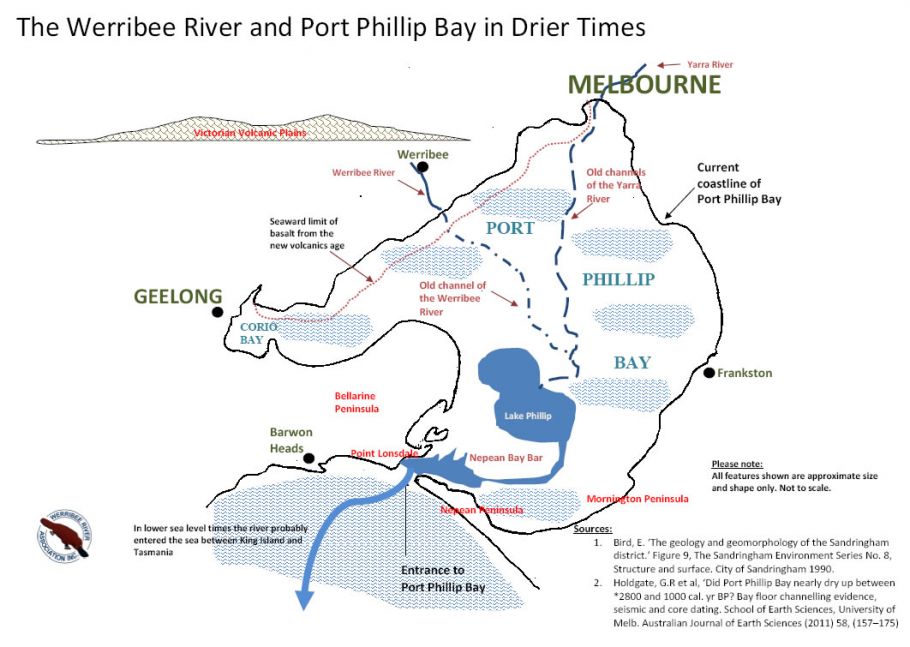
Eons ago, the Werribee River flowed from the Victorian Uplands at first in a westerly direction, then later after the time of the new volcanics was turned eastwards down onto the Victorian Volcanic Plains, and made its way south-easterly to the sea1. What of the seaward end, where it met Port Phillip Bay, what else is there to tell?
Port Phillip Bay had existed as a marine bay prior to the last ice age, and in that time had accumulated sand dunes, ridges and shoals, creating features like the Nepean Peninsula and Point Lonsdale. With the coming of the last ice age, the sea level dropped by around 140 metres, and the bay as we know it now, was a gently sloping plain.
The channels the river cut now form part of the shipping channels through the Port Phillip heads or entrance. Outside the heads, the Yarra River was joined by the Barwon River and then just above present day Tasmania, the Tamer River joined the Yarra and then flowed into the sea, westward of Tasmania’s Northwest Cape
The bay assumed its shape as we know it today about 6,000 years ago, when the sea level rose to its present level. Between 18000 and 6000 years ago, the sea level rose as a result of melting ice caps, and sea-water flowed into the bay. The shoreline became beaches, cliffs, or flats depending on the lay of the land. Beaches in the Werribee River area were formed from erosion of the new volcanic basalt as it was eroded down into silt and clay with only small amounts of grey or black sand.
History
* Prior to European occupation the area was home to the Wathawurung First Nations peoples.
* The Werribee Plains were first seen by a European when Matthew Flinders saw them from the You-Yangs in 1802.
* Hume and Hovell reached the Werribee River in 1824, naming it the Arndell.
* The first European settlement in the district took place in the mid-1830s.
* Scotsman Thomas Chirnside, already a major landholder in what is now western Victoria, took up land in the Werribee district in the late 1840s. He and his brother Andrew eventually owned 93,000 acres in the area.
* Chirnside built a homestead at Point Cook in the c.1850s.
* A Church of England school was opened in 1855.
* In 1857 a railway between Newport and Geelong stopped at Werribee.
* In 1850 the village site, which later became Werribee, was proclaimed.
* In 1861 both a National School and a Catholic School were opened in the village.
* By 1862 the Wyndham Road District had been proclaimed.
* By 1863 Thomas Chirnside controlled 28,300 ha in the district.
* The Wyndham Shire Council was established in 1862.
* The Werribee Park Mansion was built by Thomas and Andrew Chirnside between 1874-1877. It is considered Victoria’s finest colonial homestead.
* The Werribee Racecourse was built in 1879.
* A Mechanics Institute was established in the town in 1883.
* The town became officially known as Werribee in 1884.
* The Presbyterian Church at the corner of Duncans Rd and Synott St was financed by the Chirnsides in 1884.
* Thomas Chirnside committed suicide in 1887.
* In the 1890s farmers from the Ballarat area began to move into the district, establishing dairying and agriculture.
* In 1892 3,580 ha of the Chirnside estate was purchased and turned into a sewage farm.
* The shire became known as Werribee Shire in 1909.
* The production of vegetables commenced when an irrigation scheme was established c.1910.
* A local progress association was formed in 1910.
* The State Research Farm (now the Animal Research Institute) was established in 1912.
* Aviation instruction began at Point Cook in 1913-14
* Ex-servicemen were granted land in the area after World War I.
* The RAAF’s first air force base was established at Point Cook in 1921. It is believed to be the oldest continually-operating military base in the world.
* A higher elementary school was established in 1923.
* A picture theatre was built in the town in 1928.
* Werribee was proclaimed a city in 1987.
Visitor Information
Werribee Visitor Information Centre, K Road, Werribee Park Precinct, Werribee South, tel: (03) 8734 6006
Useful Websites
The dedicated local website can be accessed at https://visitwerribee.com.
References :